Thursday, April 7, 2011

Tampaksiring Palace

tampaksiring

Tampaksiring palace, located in Gianyar BALI, is only Presidential Palace that was built after Indonesia Merdeka. Tampaksiring teh palace was bulit by an architect RM Soedarsono on initiative of President Soekarno. Development of the presidential palace is devined into two periods, namely 1957 and 1963. The complex was built in 1957 is Wisma Merdeka and Wisma Yudhistira. While ini 1963, the second phase of development completed namely the Stateand Wisma Bima, and Multipurpose building.

In mountainous area, Tampaksiring was built. with an altitude of about 700 meters above sea level (DPL). The travelers who visit this place to witnes history and funktions of historic buildings that once used by the president of the Republic of Indonesia.

At Wisma Merdeka which has an area of 1200 m2, for example visitors can viewbedroom bedroom I and I, Presdent, family bedroom, living room and the space working with such beautiful arrengement. In this buliding visitors can also see the decorations in the form of sculptures and paintings of choice.

The tourists can see a bulding with an area of 1476 m2 which is the building to entertain the guest at Goverment House. Betwen Wisma Merdeka anda Wisma Negara  are as deep +15 meter gap that separates the two homestead. Therefore, built a bride along the 40 meters with a width 1.5 meters to connect two homestead it.

Guest will be escorted through the state usually this bridge to go to Goverment House, so the bridge is also known as the Friendship Bridge. The guest of honor who never pass through this bridge, among others. emperor of Japan Hirihito and Queen Juliana ot the Netherlands.

Wisma Yudhishthira is the place to stay for the party presidency and the party guests. Wisma is located in the middle Tampaksiring Palace complex has an area of ​​approximately 1825 m2. While Wisma Bima with an area of ​​approximately 2,000 m2 is usually used as the rest of the presidential guard and escort the guest country.

Another building that is not less important is the Conference Building. This building was purposely built for the purpose of the cabinet meeting, a dinner guest of the state, and important conferences, such as Summit (Summit) ASEAN XIV, held on 7-8 October 2003 ago.

Still in the palace area, the tourists can also enjoy other attractions are quite famous on the island of Bali, the Pura Tampaksiring that is right under Tampaksiring Palace. This temple is also known as the Pura Tirta Empul because in this temple are sacred springs (Tirta Empul). In this place, the tourists can do meditation and reap the blessings by way of bathing at the pond fed by water from Tirta Empul. Sacred spring that is said to have been used for purification and treatment since a thousand years ago.

From Denpasar City approximately 40 kilometers Tampaksiring Palace complex and Pura Tirta Empul located. From the capital city of Bali province, tourists can use private vehicles or public transportation (taxi). However, if want a practical sightseeing, tourists can hire the services of travel agents (travel agents) contained in Denpasar.

The travelers who require lodging hotels and resorts can be rented around Tampaksiring. For those who like shopping and culinary connoisseurs as well as to satisfy the desire on the souvenir stalls and food stalls are widely available in this region.


Monday, April 4, 2011

Keraton Ngayogjokarto | Yogyakarta Palace

keraton

It lies between the northern boundary and the monument as Stage Krapyak the south border, between Code River in the east and west Winongo River. Between Mount Merapi and the South Sea, Palace in the mind of the Javanese society, defined as the center of the world which is described as the center of the universe.

After the Treaty Giyanti, Prince Mangkubumi given region of Yogyakarta. To run his reign, Prince Mangkubumi build a palace in 1755 in the Forest Beringan. This land was considered quite good because flanked by two rivers that protect it from possible flooding. The first king in the Sultanate of Yogyakarta is the title of Prince Mangkubumi lane I (HB I).


Naming and Meaning Layout of  Palace or Kraton


keraton jogja

Palace, Palace or Kraton, derived from the word ka-queen's, which means a place to live queen / king. Broader meaning is, is described simply, that all structures and buildings in the Kraton area have significant meaning related to essential Javanese philosophy of life, namely Sangkan Paraning Dumadi (where it comes from humans and where eventually humans after death).

Outlines, in the Kraton area extending 5 km to the south until Krapyak and 2 km to the north end of Monument. On this line there is a linear line dualism inverted, so that could be read symbolically philosophical. From south to north, as the birth of human beings from on high to the mortal nature, and vice versa as the return man to the side Dumadi (God in view of Java). Meanwhile, a physical with the king's palace as a symbol of true soul that comes into the physical body.

Palace to Tugu also be interpreted as a way of life full of temptation. Beringharjo market symbolizes women temptation. While the temptation for power is symbolized by House Kepatihan. Both are located on the right. Straight road itself as a human symbol close to the Creator (impressive Paraning Dumadi).

Put simply, the monument symbolism Linga (male) and Krapyak as Yoni (female). And the Palace as the physical origin of the two.
Spatial meaning Kraton

Hit by the earthquake in 1867, the Palace was severely damaged. At the time of HB VII in 1889, the building is refurbished. The lay still retained, but the shape of the building changed as it looks now

Monument and Ward or Ward Manguntur Tangkil Kencana (where the king's throne), located in a straight line, this means, when the Sultan sat on his throne and looking toward the Tugu, then he will always remember the people (subjects manunggaling gusti).

Kraton Kraton same order as the Mataram dynasty in general. Kencana ward which became the king's reign, together with Ward Prabayeksa as a place to store weapons Palace heritage (in this room there Wiji Kyai oil lamp, which is always guarded to prevent outages courtiers), serves as a center. The ward is covered by the court Kedhaton, so to reach the center, pass through a page that resembles a series of layered bewa (waves) above the ocean.

Special arrangement of the Palace is very similar to the constellation of mountains and plains Cashew Dwipa, seen as a continent of its center of the universe.

From north to south of the palace there are successive North Square, North Hinggil Siti, North Kemandhungan, Srimanganti, Kedhaton, Kemagangan, South Kemandhungan, Siti Hinggil Square South and South (the sheltered courtyard wall height).

While the door to go through to get to each place of nine, called Regol. From there north gate, pangurukan, Tarub great, brajanala, srimanganti, kemagangan, gadhung Mlati, kemandhungan and ivory.

Brongtodiningrat looked at these numbers is important, as the highest number that describes perfection. This corresponds to nine holes in human beings, commonly called babahan hawa sanga.

The sacredness of each Palace building is indicated by the frequency and intensity of the Sultan at the venue.

Square, Exhibition, and Siti Hinggil, in place of Sultan only comes three times a year, namely during the events of Pisowan Ageng Grebeg Maulud, Sawal and Besar. And the opportunities so incidental a very special example when the coronation of the Emperor and Crown Prince or Princess Coronation Duke Anom.

Sultan's Palace is an old building that was once damaged and restored. Looks like other Kingdom buildings. But if we explore the sultan's palace, which is the largest and most beautiful examples with symbolic meaning, a philosophy of life, human nature, how nature works and human beings live their lives and various symbols of life existence in them.

adat jogja
abdi dalem


Saturday, April 2, 2011

Tana Toraja

tana toraja

Tana Toraja is one of the Indonesian tourist attraction, inhabited by a tribe who inhabit the mountains of Toraja and maintaining a distinctive lifestyle and still show the original Austronesian lifestyle and culture are similar to Nias. This area is one tourist attraction in South Sulawesi, which is very interesting and you should not miss.

The following is a list of some interesting places that you might visit:


Pallawa.

pallawa

Tongkonan Pallawa is one tongkonan or traditional house that very interesting and among the tree-pohin banbu on the hilltop. Tongkonan is decorated with a number of buffalo horn that is attached at the front of traditional house. Located about 12 km to the north of Rantepau.


Londa.

londa

Londa is the steep rocks on the side of a typical tomb Tana Toraja. One was located on high ground from the hill with a cave in which the corpse crates are set according to the family line, the other one left open hillside views overlooking the green expanse. Located about 5 km to the south of Rantepau.


Ke'te kesu

ke'te kesu
.
The object of this charming village of Tongkonan, rice barns and buildings in the surrounding megaliths. About 100 yards behind this village there is a cliff with the grave cemetery site dependent and tau-tau in a given building stone fence. Tau-tau shows the daily appearance of the owner. This village is also known as carving skills possessed by its inhabitants as well as a great place to shop for souvenirs. Located about 4 km from southeast Rantepau.


Stone Tumonga.

tumonga

In this area you can find about 56 stone menhirs in a loop with 4 trees in the middle. Most stone menhir has a height of about 2-3 meters. From here you can see the beauty rantepau and the surrounding valley. Located in the area Sensean with ketinggai 1300 Meters above sea level.


Lemo.

lemo

This place is often referred to as the home of the spirits. In the cemetery you can see the corpses Lemo yanng stored in the open air, amid the steep rocks. This cemetery is the combination of death, art and ritual. At certain times clothing from the bodies will be replaced with a ceremony Ma Nene. Located in District Tan Toraja.

Wednesday, March 30, 2011

Lake Toba | North Sumatra

Incomplete feel if you visited the North Sumatra did not stop for a moment to Lake Toba, volcanic lake which is the largest lake in Indonesia, and even Southeast Asia. Exotic charm vast expanse of the lake like a sea with shady trees and hills, charming. The lake, measuring 1700 square meters with a depth of approximately 450 meters and lies 906 meters above sea level, in the middle of the lake there is Samosir Island became the object of not less interesting excursions.

toba1

During his visit in 1996, Prince Bernard of the Netherlands even expressed his admiration for the beautiful panorama of the lake. "Sell me name to this lake. I can not describe how beautiful Lake Toba, "he says enthusiastically.
There are seven districts around the lake, namely Simalungun, Toba Samosir, North Tapanuli, Humbang Hasundutan, Dairi, Karo, and Naidoo who has a wonderful natural panorama and a tourist destination location. Generally, tourists enjoy the beauty of Lake Toba Parapat in Simalungun and Tuktuk Siadong on Samosir Island.

It is estimated that Lake Toba explosion occurred at about 73 thousand-75 thousand years ago and is a super volcano eruption (super volcano) the most recent. Bill Rose and Craig Chesner from Michigan Technological University estimate that volcanic materials spewed out of the mountain as much as 2800 km ³, with 800 km ³ of rock Ignimbrite and 2,000 km ³ of volcanic ash which is expected in the wind to west for two weeks.

toba2

Volcanic dust in the wind has spread to half the earth, from China to South Africa. Explosion occurred during the week and throw the dust up to 10 km above sea level.

This incident caused mass death and, in some species, also followed by extinction. According to some DNA evidence, this eruption also reduced the number of people to about 60% of the total human population of the earth at that time, which is about 60 million people. The eruption was also contributed to the occurrence of ice ages, although the experts still debate.

After the eruption, the caldera formed which is then filled with water and became what is now known as Lake Toba. Pressure upward by magma that has not come out cause the emergence of Samosir Island. While enjoying the beauty of this lake, you might not imagine that the charm of the place comes from the catastrophic volcanic eruptions that brought fear and horror at the time.

Travel overland to Lake Toba, precisely to Parapat, takes four to five hours from Medan. Available bus or travel directly to Parapat. The route through the Lubuk Pakam, Cliff High, and turn toward Siantar. Along the way, we were treated to a panorama of palm oil and rubber plantations.

When using the train, from Medan select a route to Siantar. From here the journey continues by bus to Parapat. Left sails through one hour.

For a place to stay and stay longer to enjoy the beauty of Lake Toba, there are many hotels and inns. In Parapat, there are at least 900 hotel rooms of all types, ranging from four star to homestay, in Tuktuk also not different. Both in Parapat and Tuktuk, tourists can instantly enjoy the lake from the rim. Rates for hotels in Parapat Tuktuk and varied, according to typical tourists who come. Starting from Rp 30 thousand to USD 500 thousand per night depending on the type of hotel.

A travel companies even offer to enjoy the beauty of Lake Toba from the air, ie use paragliding. Every tourists are given the opportunity to fly using the paragliding from the mountains Tongging, Karo District, North Sumatra. For tourists who want to try paragliding will be accompanied by an experienced instructor, but of course determination can fly or not depends on weather conditions and wind.

Not only that, enjoy the beautiful sunrise and sunset you can enjoy from the coastal lakes. From the Karo highlands on the north, the lake looks elongated beauty viewed from Sikodonkodon. However, there is only one resort here. On the west side, views of the lake and the island of Samosir can be perfectly seen from the Tele. There is a viewing post at an altitude of about 1,000 meters from sea level to enjoy the sunset on Lake Toba.

Bunaken

Ever fancy yourself being a mermaid? Being able to swim along with other creatures of the sea , moving to the rhythm of the waves? In the Bunaken Marine Park, you will encounter a real “mermaid”, and you can also get a glimpse of sea life here.

bunaken map

Bunaken is an 8.08 km² island in the Bay of Manado, situated in the north of the island of Sulawesi, Indonesia. Bunaken forms part of the administrative city of Manado , capital of North Sulawesi. The marine Park around Bunaken is part of the  National Park that also includes the ocean around the island of  Manado Tua – or Old Manado, Siladen and Mantehage.   

bunaken1

Within the Bunaken Marine Park, visitors can see various strange and colourful marine life along its sea bed. To reach this park, you can take a motorboat. The journey from Manado takes around 40 minutes.  Entrance fee is 25,000 rupiahs per person per visit.

The translucent waters of the Bunaken seas enable people to clearly view numerous sea biota. There are 13 species of coral reefs in this park, dominated by edge ridges and block ridges of rocks. The most attractive view is the steep vertical sloppy coral reef that plunges down as deep as 25-50 meters.

bunaken2
bunaken ecky

Feast your eyes on 91 types of fish found in the Bunaken National Park, amongst which are the locally known gusimi horse fish (Hippocampus), the white oci (Seriola rivoliana), yellow-tailed lolosi (Lutjanus kasmira), goropa (Ephinephelus spilotoceps and Pseudanthias hypselosoma), ila gasi (Scolopsis bilineatus) and others.

Divers may also meet mollusk like the giant kima (Tridacna gigas), goat head (Cassis cornuta), nautilus (Nautilus pompillius) and tunikates/ascidian.

For those who enjoy scuba diving, this is a great place to be. With about 20 dive spots to choose from, divers will have the chance to swim below the sea, and frolic joyfully while admiring the sea creatures.

Make sure to visit Bunaken during its best season between May to August. That way you can explore the Park  to its fullest.

Borobudur Temple

Who does not know Borobudur? This Buddhist temple has 1460 relief panels and 504 Buddha effigies in the complex. Millions of people are yearning to visit the buildings included in this World Wonder Heritages. No wonder, for the architectural and function as a place of worship, Borobudur is attractive heart.
Borobudur was built by King Samaratungga, one of the kings of Old Mataram Kingdom, Dynasty descendant dynasty. Based Kayumwungan inscription, an Indonesian named Hudaya Kandahjaya revealed that Borobudur is a place of worship was completed on 26 May 824, almost a hundred years from the time the construction. The name of Borobudur, as some people means a mountain having terraces (budhara), while the other says that Borobudur means monastery on the high ground.

borobudur1

Borobudur-shaped building with staircase punden consists of 10 levels. Height 42 meters before it was renovated and 34.5 meters after the renovation because the lowest level is used as a drag. Six lowest level of a square and three levels on top of a circle and one of the highest level of Buddhist berupastupa facing westward. Each level represents the stages of human life. In accordance madhhabs Mahayana Buddhism, every person who wants to reach the level as the Buddha had to through every level of life is.
The base of Borobudur, called Kamadhatu, symbolizing human beings that are still bound by lust. Four levels above referred Rupadhatu symbolizes man who had to break free from lust but still bound manner and form. On this terrace, Buddha effigies are placed in open space. Meanwhile, three levels above where the Buddha is placed in a perforated dalamstupa called Arupadhatu, symbolizing man who has been free from lust, appearance, and shape. The top part is called Arupa symbolizes nirvana, where Buddha is residing.

borobudur2

Each terrace has beautiful relief panels showing how skillful. Relief that will be read coherently when you walk in a clockwise direction (towards the left of the entrance of the temple). The relief panels tell the legendary story of Ramayana. In addition, there are relief panels describing the condition of society at that time. For example, relief of farmers' activity reflecting the advance of agriculture system and relief of sailing boat representing the advance of the voyage who was based in Bergotta (Semarang).
All relief panels in Borobudur temple reflect the Buddha's teachings. Hence, this temple functions as educating the media for people who want to learn Buddhism. YogYES invites you to surround each narrow alleys diBorobudur for to understand the philosophy of Buddhism. Atisha, a Buddhist from India in the 10th century, had visited the temple that was built 3 centuries before Angkor Wat in Cambodia and 4 centuries before the Grand Cathedrals in Europe.
Thanks to visiting Borobudur and armed with a script from Serlingpa Buddhism (one of the king of the Kingdom of Sriwijaya), Atisha was able to develop Buddhism. He became head Vikramasila monastery and taught Tibetans of practicing Dharma. Six manuscripts of Serlingpa was condensed into a core course called "The Lamp for the Path to Enlightenment" or better known by the name Bodhipathapradipa.
One of the questions still unanswered about Borobudur is how the condition around the temple was built and why the temple was found in the buried state. Some say Borobudur initially stood surrounded by a swamp and then buried by the eruption of Merapi. Calcutta is essentially the inscription reads 'Amawa' means sea of ​​milk. The word is then interpreted as lava of Merapi. Some of the others buried mengatakanBorobudur cold lava of Merapi.
With all the grandeur and mystery that is, only natural that many people from all world penjru include Borobudur as a place worth visiting in his life. Besides enjoying the temple, you can walk around to the villages sekitarBorobudur, like Karanganyar and Wanurejo to view the activities of local crafts. You also can go to the top watu Kendil to be able to view panoramaBorobudur from above. Why wait? No need to worry about an earthquake May 27, 2006, because of Borobudur is not affected at all.
Borobudur is one of the best ancient monuments are preserved from all over the world even is one of the seven wonders of the world. This monument is the largest Buddhist temple in the world and has been claimed as a result of human culture is the most frequently visited by more than a million tourists, both domestic and abroad to date. Style architect even this daricandi resembles nothing in the world. The structure that describes the micro-cosmos terisnpirasi that often arise to a question, for example when, in what way, how long and by whom these nature reserves have been built.
The appropriate response to this still leaves a mystery since no written documents to date. Based on the inscriptions found by the researchers, noted bahwaCandi Borobudur was built between the eighth century when Samaratungga - king of the dynasty ruling dynasty in Central Java. The meaning of Borobudur is still not clear. Borobudur is a combination of words and Budur Bara. Bara from Sanskrit means temple or monastery complex. While the Budur remind us with that derived from the Balinese word meaning beduhur above. In other words, Borobudur means monastery on the hill.

borobudur3
borobudur4

Borobudur is full of philosophical ornaments in which clearly symbolizes the unity of the different paths can be followed to achieve the goal of life's most pokok.Relif etched into the dindingcandi notify the beauty in studying life. In other words, Borobudur has a soul of art, philosophy and culture.

Komodo Island

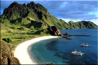
For those of you who like to travel, you definitely do not want to spend an impressive tourist attraction all over the archipelago. Adventure to the exotic islands, dive into the azure, and bathed in sunshine will make your holiday unforgettable. Imagine, you have a chance to see traces of past life are preserved, whose role and maintain its sustainability. You and your family feel at home not only to enjoy its natural attractions, but also proud to be part of the diverse beauty of Indonesia. And here, on Komodo Island National Park, East Nusa Tenggara, you will get everything.


Komodo Island is located at the westernmost tip of East Nusa Tenggara Province, which borders West Nusa Tenggara Province. Exactly at Komodo district, West Manggarai regency, East Nusa Tenggara, Indonesia. Since 1980, an area of ​​1817 km2 National Park was made by the Government of Indonesia, which is then recognized by UNESCO as a World Heritage Site in 1986. Together with two other large islands, namely Pulau Rinca and Padar, Komodo Island and several small islands around it continued to be maintained as natural habitat reptile, dubbed "Komodo Dragon" is.

komodo island


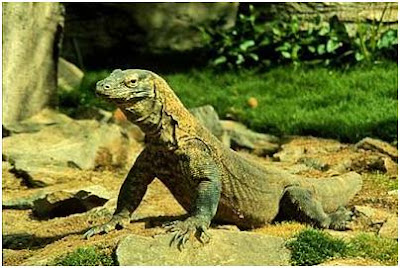
Bearing the Latin name Varanus komodoensis and local name "Ora", giant lizards, according to a story first published in 1912 in a national daily the Dutch East Indies. Peter A. Ouwens, director of the Zoological Museum in Bogor is one who has introduced his paper dragons to the world through it. Since then, expeditions and research on endangered species continue to be done, even reportedly inspired the film had Zone Symbian soft updates in 1933. Recognizing the need for protection against the dragon in the center of human activity in its habitat that, in 1915 the Dutch government issued a ban on hunting and killing dragons.


Thanks to the efforts of government and local communities in conserving the National Park, tourists come to visit and now a close look at the life of these ancient reptiles. With a body length of 2-3 meters, Komodo dragons can weigh up to 70-100 pounds. Animals who likes hot and dry place to live in a tropical forest or savanna habitat at low altitude. When night fell, dragons nest in the hole with the 1-3 meter while keeping body heat at night. As a carnivore at the top of the food chain, prey Komodo include goats, deer, wild boar, and birds. In certain circumstances, can behave cannibal with Komodo dragons prey on another. With the sense of smell relies on his tongue, the Komodo dragon can smell carrion prey as far as 9 kilometers. Bites which can contain bacteria and deadly, plus a sharp front claws are natural weapons. In addition, the dragons were able to run 20 kilometers per hour in short distances, climbing trees, swimming and even diving.


Just like other reptiles, the Komodo dragon reproduce by laying eggs. However, studies prove there are other ways to regenerate dragons, namely by means of parthenogenesis. This method allows the female dragons to produce fertilized eggs without the male. Komodo dragon parthenogenesis alleged to have been saved from extinction since thousands of years ago. However, destruction of habitat, volcanic activity, earthquakes, fires, until the poaching has resulted in a decrease indicated a population of dragons to some extent vulnerable to extinction. An estimated 4-5 thousand dragons tail in the presence of productive females only numbered in the hundreds. This condition is a challenge for conservation efforts Komodo Island National Park.


Enjoy a tour of Komodo Island National Park to observe the life of Komodo dragon up close may not be enough for you. For those of you who like to water sports, you can try to dive in the waters north and south islands. The waters north of the warm waters of the current meeting of the Banda Sea and Flores. In contrast, the southern waters offer the cold waters of the Indonesian Ocean currents. The combination of these two different characters these waters produce a rich underwater ecosystem. Various types of coral reefs and fertile life into a place to live so many species of fish and provider of marine aquatic life support systems. Many divers have witnessed life under the sea waters of the charming island of Komodo, which saves millions of potential biodiversity.

komodo

As one of the attractions are Indonesia, Komodo Island hostels provide accommodation ranging from established local communities to international standard resorts. For domestic tourists, you are charged entrance fee of Rp. 75,000, while foreign tourists amounted to U.S. $ 15. To reach the island of Komodo, you can route a plane from Kupang (capital of East Nusa Tenggara, East Nusa Tenggara) to the town of Ende on Flores Island. Next trip continued with a minibus to Labuhanbajo which takes 10 hours. From Labuhanbajo, speedboat will take you to Komodo Island after a ferry for 2 hours. Several other routes you can travel with a flight from Bali as the airlines that serve the purpose to NTT. Various tour packages offered by travel agents it's quite interesting to try for the first time you visit this island of Komodo.


Eco-tourism is proclaimed by the government against the island of Komodo National Park is expected to bring more domestic tourists / foreign countries. Not only parents, even though children should not be afraid to come and visit there. With regulations and safety tour of awake, humans and dragons co-exist in peace. And like children, their love of dragons are the seeds that can grow their love for the land property and its history. It seems that this is the first message in the 90's never sung with beautifully by Kak Seto Si Komo through her dolls. Through the character of Si Komo, Kak Seto brings dragons conservation message to heart and mind the children of Indonesia, for they are proud of the wealth of his country.


Thus, it seems worthy of Komodo Island National Park became one of the 7 Natural Wonders (7 Wonders Of Nature), coupled with a variety of other amazing wonders of the world. Traces the life of the ancient world has presented himself to the people today to look in the mirror to see the past history of the world. The life that has passed hundreds, even thousands of years. Through this Komodo Island National Park, the world today has a priceless heritage to be preserved. Let's support Komodo Island National Park into one of the 7 Wonders of Nature. Thus, you have participated in an attempt to introduce the Komodo National Park to the world, so that conservation is not just a concern of Indonesia, but the entire world community. Komodo Island National Park Vote for 7 Wonders of Nature.

So, have you decided on a family vacation destination this time? Of course, the answer Komodo Island National Park. Only the one in the world. Only in Indonesia.

Tuesday, March 29, 2011

Raja Ampat | Marine Park

Who says in the Papua nothing spectacular marine tourism object? So far, Papua better known simply exotic culture and natural resources are abundant. However, come to Raja Ampat, and enjoy the beauty of the coral reef, complete with captivating marine life and marine scenery impressive.

raja ampat1

Nothing wrong when the then Miss Indonesia 2005 Nadine Chandrawinata expressed his admiration for the region after the dive, feeling the grain panoramic underwater Raja Ampat are very alluring. Snorkeling and diving enthusiasts are guaranteed not to be disappointed. Instead, they would be called to come and come again.

Raja Ampat is a fraction Sorong, since 2003. District has a population of 31 thousand souls has 610 islands (only 35 islands are inhabited) with a total area of ​​about 46,000 km2, but only 6,000 km2 of land, 40,000 km2 in the sea.

The islands are unspoiled and the sea is still beautiful to make direct tourists hooked. The archipelago is located in northwest New Guinea bird's head, with approximately 1500 small islands and atoll and 4 major islands, namely Misol, Salawati, Bantata and Waigeo. This then makes the Raja Ampat's largest marine park in Indonesia.

This area had been targeted by poachers by reef fish bombing and cyanide poison to spread. However, there are still many people who attempt to protect the region so that the wealth of the sea could be saved. Coral reefs in Raja Ampat is considered the most complete sea in the world. Of the 537 coral species of the world, 75 percent were in these waters. Also found 1104 species of fish, 669 species of molluscs (soft animals), and 537 species of coral animals. Incredible!

raja ampat2

The World Bank in collaboration with global environmental institutions establish Raja Ampat as one region in East Indonesia, which received assistance Coral Reef Rehabilitation and Management Program (Coremap) II, since 2005. In Raja Ampat, this program covers 17 villages and involve the local population. Fishermen are also trained to cultivate fish, grouper and sea grass.

Especially for you who are not interested in diving activities, the blue expanse of ocean that refract the beauty of the sky, a sprinkling of white sand that radiate like a pearl sheen, can be enjoyed. In addition, there are group of islands with a fascinating and unique flora and fauna such as red paradise, paradise Wilson, maleo Waigeo, various parrots and parrot, possum Waigeo, as well as various types of orchids.

Diving on the island of Papua Mansuar is one of the leading resorts in this region. Foreign tourists diving enthusiasts at home for days in a month even enjoy the beauty of Raja Ampat's there and stay in Papua Diving.
raja ampat3

Maximillian J Ammer, a Dutch citizen of Papua Diving Resort owners are also pioneers of marine tourism drive this region, need desperately to set up various facilities to attract tourists from abroad. Since starting his business eight years ago, many of the funds must be spent. However, the results are also satisfactory. Each year the resort is visited at least 600 special tourist who spent an average of two weeks.

Lodging is very simple that only a walled and roofed woven palm leaves that cost at least 75 euros, or Rp 900,000 a night. If you want to dive must pay 30 euros, or approximately USD $ 360,000 once a dive at one particular location. Most tourists come from Europe. Only a few tourists from Indonesia to stay and dive in there.

Kri Island, Waigeo, and Misool also prepare the resort for visitors. On the island there Misool Eco Resort is built by applying the principles of strict nature conservation. There are agreements with indigenous populations around the region to maintain an integrated ecosystem-called "No Take Zone" which prohibits any taking of marine exploitation, ranging from hunting shells, turtle eggs, shark's fin to just fishing. In the extreme, even in eco resort prohibits the use of antiseptics as waste exhaust feared would kill the coral reef ecosystem in the vicinity.

raja ampat4

Some resorts are relatively expensive to set prices for presenting a complete facility. Travelers with limited costs can also take advantage of government-owned resorts are much cheaper in the area Waisai, the capital of Raja Ampat.

You have to fly first to Airport Domne Eduard Osok, Sorong, Papua, and then directly to the location by speed boat with a capacity of about 10 people at a rate of Rp 3.2 million each way. It takes about 3-4 hours to reach the area of ​​Raja Ampat Islands in particular to Mansuar.

To get around the island you want, we can hire a speedboat capacity of 10 persons with a price of USD 3-5 million per 8 hours, depending on the intelligence we offer. We can also take a package tour by visiting the village to see typical local plants and animals such as birds of Paradise.

To enter the area of ​​Raja Ampat, each person must pay an entrance fee of Rp 250 thousand for domestic tourists, and $ 500 thousand for tourists from abroad. A round pin that serves as this identity we will receive, after paying the fee.
Uniquely, the pin is valid for one year, from 1 January to 31 December. So if in one year that we go back and forth to visit Raja Ampat, only need to pay an entrance fee only once. Of course, the pins were not allowed to be lost and should we wear as identification.

Sea Olele, Gorontalo

The beauty of Indonesian marine was second to none. Not surprisingly, marine tourism Indonesia has always led to a sense of curiosity for the hunter marine tourism. One of them is Olele Marine Park, located in Gorontalo, Gorontalo province. State of Indonesia which has an area of ​​ocean over 3,257,483 km ², indeed attract every tourist, whether domestic or foreign. Not only the natural beauty of blue sea stretches, but also a variety of views of the sea floor that ciamik on earth can you enjoy the motherland. One of them contained in the Marine Park Olele.

sea olele

Marine Park is located in the Village Olele Olele, District Kabila Bone, Bone Bolango District, Gorontalo, Central Sulawesi. Precisely located about 20 km south of capital city of Gorontalo. If you ever visit the Bunaken Marine Park, about a scene like that is what will appear on the seabed which is captivating. However, this area looks more natural and dazzle every eye that sees. No wonder, because once you set foot there, dozens of dolphins seemed to welcome the joyful at sea level.

deep sea olele

Olele plumbed the depths, you can find many beautiful reefs that adorn the bottom of the sea. Blue ocean water looks clear, as if teasing the presence of each guest to try it. This place, it's always been the target of sea sports lovers from all over the world. Because, there, the environment is still so natural. The beach is also not so crowded, when compared with other Marine Park. Olele Sea is so beautiful. Foreign tourists often visit the Marine Park Olele to adrenaline through diving and snorkeling.

For those who like sea sports, it seems this place will become your favorite location. Because you can complete the diving and snorkeling in the sea is calm. Local government also has approved the area as an arena for Fun diving and scientific diving. Please satisfy yourself working out there. If you just want off fatigue, you can see dozens of beautiful marine life. Charming scenery can be seen by renting a boat glass, so you can enjoy the underwater paradise that area of ​​the eye could see.

6 Typical Festival in Indonesia

Indonesia is often referred to as the sleeping giant of Southeast Asia, and the epithet was indeed appropriate. With more than 18 thousand islands, this archipelago has a remarkable diversity of what you can see or do while on vacation there.

Modernization brings a wide range of development (some say excessive development) to Jakarta, while the Bali tourism back to life after being destroyed when a bomb blast 2002. There are also mountains such as Borobudur Bromo and the mystical to search various types of attractions, as well as the 6000 inhabited islands.

Not surprisingly, Indonesia offers the festival a very distinctive feature of their culture, reflecting the ethnic diversity and traditions from various parts of the archipelago. You'll find this diversity in Indonesia is typical of six festivals, ranging from the celebration of art, batik, dance and ceremony. If possible, you can witness one of the festival during his visit to Indonesia!

Krakatau Festival

Krakatau Festival is an annual festival held in Lampung, was held to celebrate the volcanic island of the same name, Krakatoa. Mount Krakatoa erupted in 1927, the eruption was then produce a new small islands, named Anak Krakatau.

krakatoa

During the festival, visitors can enjoy variety shows like Carnival Tuping (Carnival Mask Lampung), elephant and various dances from Lampund and surrounding cities. End of series of events is a visit to the volcanic island, was still active but was sleeping soundly. For a while!

Bali Arts Festival

One of the largest annual celebration of art and culture in Indonesia, Bali Arts Festival is always packed. During the month, various art performances, exhibitions, and other cultural activities will take place in Bali, offering dance, music and beauty of their culture.

tari joger

Celebrations famous attractions such as traditional dances that have been almost forgotten, traces of the remote areas of Bali, food, handicrafts, as well as new creations from dance schools in Denpasar and contemporary choreography of national and international artists.


Solo Batik Carnival

Since time immemorial, batik tradition has always had very strong roots in Solo. Kotadi Central Java has made it even batik as an icon and identity, an accurate picture of a city famous for its beauty and subtlety of his kingdom
behavior. Solo Batik Carnival was held to reinforce that tradition, and to promote batik on national and international scale.

batik

This event is a combination of ceremonies, fashion shows and carnivals, all using batik as a theme. There will also bazaar that offers a variety of unique batik and souvenir Solo.


Solo International Ethnic Music Festival
One of the latest festival of Solo is the Solo International Ethnic Music (Siem) Festival, which focuses on performances and celebration of ethnic music. This event is a unique platform for collaboration between modern and ethnic music, local artists and international.

gamelan

The long list of performers including artists Minangkabau, Riau, Yogyakarta, Surabaya, Papua, Kalimantan, and even foreign artists from Japan, Australia, India, New Zealand and many others.

Gerebeg Mulud

In the Java language, meaning gerebeg Mulud crowd and is one calendar month name in Java. The celebration, also known as Sekaten, to celebrate the birth of the Prophet Muhammad. The procession lasted all day and 'featuring' two gamelan performances which paraded toward the grand mosque.

gerebeg mulud

In the evening there will be a market in the northern city to add a festive city, the perfect place to try different foods Java and Yogyakarta as well as to hunt for souvenirs.


Baliem Festival

Papua typical festival has its roots in the beliefs of local tribes that the war not only conflict keuasaan and interests, but also a symbol of fertility and prosperity. Since 20 years ago, local governments have stressed the importance of peace between the tribes who fought to prevent retaliation and prolonged loss of life. So Baliem Festival is an event that was held to replace the war between the tribe.

baliem

As you may have guessed, the main event is a war between tribes. Imagine more than 20 different tribes each with 30 to 50 people wearing traditional clothing, carrying spears, bows, arrows and machetes! There are also performances and a host of other attractions, such as local traditional games, dances, as well as local cuisine.

Mount Bromo

The existence of Mount Bromo with sea sand has been quite phenomenal long been known as one of the leading tourist destination in Indonesia. Mount Bromo is one of the mountain on the Tengger Mountains.

With a height of 2392 meters above sea level, beautiful panoramic views emitted when the natural charm that will never-ending. Mount Bromo is derived from Sanskrit which means god Brahma or a major and are located in four regions, namely Probolinggo, Pasuruan, Lumajang, and Malang.

bromo

The attraction of Mount Bromo crater special is in the middle of the vast sea of ​​sand that stretches around the crater of Bromo, white smoke. Mount Bromo mesh body shape between valleys and canyons with the caldera or the sea of ​​sand covering some 10 square kilometers.

Mount Bromo has a crater with a diameter of ± 800 feet (north-south) and ± 600 meters (east-west). While the danger area of ​​a circle with a radius of 4 km from the central crater of Bromo. The height of the relatively "low" for the size of the mountain to make the trip to Mount Bromo is relatively easy.

From the top of the volcano is still active, you can enjoy the vast expanse of ocean sand, and watched the towering majesty of Mount Semeru reaching for the sky. You also can look beautiful sun went out of peraduannya or otherwise enjoy the dim twilight of the ridge Bromo.

To view them, you have to climb Mount Pananjakan which is the highest mountain in the region. Terrain that must be traversed to get to Mount Pananjakan quite heavy. To reach the foot of Mount Pananjakan, you have to go through desert-like area that can make you get lost. When the need to climb Mount Pananjakan, narrow streets and many sharp turns, of course requires a high driving skill.

For that, many visitors who choose to rent a car hardtop (a type of jeep) driven by the community. Surrounding communities come from the Tengger tribe was friendly with the visitors. Up above, there are many shops serving coffee or tea and a fire to warm themselves while waiting to tebitnya sun. There are also stores that rent warm clothing.

gunung bromo

Watching the sunrise is an interesting event. Evidence, the visitors are willing to wait since 5 am facing the east so as not to lose this moment. You also do not always able to see this event, because if the cloudy sky, the appearance of the sun is not seen clearly.

However, when the sky is clear, you can see the roundness of the sun first of all just as small as a match pins, slowly enlarge and eventually form a full circle and give information so that we can see the views of the mountains in this region. Among others, Mount Bromo, Mount Batok, or Mount Sumeru which is the highest mountain in Java.

The history of the formation of Mount Bromo and the mountains around it originated from the existence of Tengger Mountain (4,000 meters above sea level) which is the largest and highest mountain at that time.

Then came the massive eruption which created a caldera with a diameter of more than 8 kilometers. Material volcanic eruption is now transformed into a sea of ​​sand, the material is said to have covered by water. The volcanic activity with the advent of the hall lead to the formation of magma new mountains such as Mount Bromo, Mount Widodaren, Gunung Batok, Gunung Watangan, Mount Chairs and Mount Semeru.

mount bromo

Bromo does have its own uniqueness compared to other mountain panorama. In the vicinity of Bromo until the peak does not exist other than green plants shrubs. Mount Bromo is still contained in the Bromo Tengger Semeru National Park is also the only conservation area in Indonesia, which has a unique form of sea sand area of ​​5250 hectares.

To reach the foot of Mount Bromo, you can not use the vehicle. Instead, you must hire a horse with a price of USD 70 thousand, or if you feel strong, you can choose to walk. But, it should be noted that walking is not easy, because of the scorching sun, a far distance, scattered dust can make the journey harder.

From the foot of the mountain was phenomenal, you have to climb the ladder whose numbers reach 250 stairs to see the crater of Mount Bromo. Arriving at the top of Bromo, you can see the crater of Mount Bromo that emit smoke.

You can also glanced down and saw the sea of ​​sand with a temple in the middle. After lingering at the top, if travelers are feeling hungry, at the bottom of the Bromo there are stalls offering warm, instant noodles, mineral water and cheap snacks. .

Besides watching the beautiful panorama offered by the Bromo-Semeru, if you come at the right time, then you can watch Kesodo ceremony, which was held by Tengger society. This ceremony usually begins at midnight to early morning every full moon around 14 or 15 in Kesodo [tenth] according to the Javanese calendar.

Kesodo ceremony is a ritual to invoke the abundant harvest or decline the request for reinforcements and cure various diseases, in particular by offering offerings and threw it into the crater of Mount Bromo. When the procession took place, other Tenggerese rollicking down the cliff of the crater and the offerings being thrown into the crater, as a symbol of blessing from the Almighty.

There are a few tips that need your attention now to the region of Mount Bromo, among others, Have a look in the dry season, not the rainy season, so you will get a perfect view of the moment. Prepare cold protective clothing, such as the guard house, slayer, scarves, gloves, jackets, and do not forget the shoes because the weather is quite cold here. Also take glasses to shield from dust while in Segoro Wedi sand. Do not be in the crater of Bromo on top at 9 am to avoid the risk of poisoning.

There are four main gate to enter the Bromo Semeru national park areas are: Village Cemorolawang if through the Probolinggo, Pasuruan Village Wonokitri with lines, Ngadas Village and Village of Malang path is the path Lumajang Burno.

The route can be taken is as follows:
- Pasuruan-Cafes-Tosari Dowo Wonokitri-Bromo-use cars with a distance of 71 km,
- Malang-Shack-Tumpang Klakah Jemplang-Bromo-use cars with a distance of 53 km
- Malang-Purwodadi-Nongkojajar-Tosari-Wonokitri-Penanjakan about 83 km